Grassroots Innovation Using Drones for Indigenous Mapping and Monitoring


1
Centro de Investigaciones en Geografía Ambiental, Universidad Nacional Autónoma de México, Antigua carretera a Pátzcuaro No. 8701, Morelia CP 58190, Michoacán, Mexico
2
School of Economic, Political and Policy Sciences, University of Texas at Dallas, 800 West Campbell Road, GR 31, Richardson, TX 75080-3021, USA
*
Author to whom correspondence should be addressed.
Land 2017, 6(4), 86; https://doi.org/10.3390/land6040086
Submission received: 2 November 2017
/
Revised: 2 December 2017
/
Accepted: 4 December 2017
/
Published: 7 December 2017
Abstract
:Indigenous territories are facing increasing pressures from numerous legal and illegal activities that are pushing commodity frontiers within their limits, frequently causing severe environmental degradation and threatening indigenous territorial rights and livelihoods. In Central and South America, after nearly three decades of participatory mapping projects, interest is mounting among indigenous peoples in the use of new technologies for community mapping and monitoring as a means of defense against such threats. Since 2014, several innovative projects have been developed and implemented in the region to demonstrate and train indigenous communities in the use of small drones for territorial mapping and monitoring. In this paper, we report on five projects carried out in Peru, Guyana, and Panama. For each one we describe the context, main objectives, positive outcomes, challenges faced, and opportunities ahead. Preliminary results are promising and have gained the interest of many indigenous societies who envision this technology as a powerful tool to protect their territories and strengthen their claims regarding specific environmental liabilities and justice issues. Based on the results presented here and a review of previous similar studies, we offer a critical discussion of some of the main opportunities and challenges that we foresee regarding the use of small drones for indigenous territorial mapping and monitoring. In addition, we elaborate on why a careful, well thought-out, and progressive adoption of drones by indigenous peoples may trigger grassroots innovations in ways conducive to greater environmental justice and sustainability.
1. Introduction
Despite significant progress toward the formalization of indigenous territorial rights in Central and South America since the 1990s [1,2], indigenous territories in the region are increasingly threatened by neoliberalism [3,4,5]. Some of these threats originate in the region’s profoundly skewed land distribution, where 1% of agricultural proprietors hold more than half of productive land and concentration continues to rise, making Central and South America the most unequal region on Earth [6]. Different forms of land grabbing are exacerbating this concentration, often at the expense of indigenous peoples, who may be forcibly evicted from their territories following land deals [6,7,8]. The extractive imperative in the region [9] tends to clash with indigenous territorial rights as concessions often intrude on their territories [10], and the social and environmental liabilities of these industries are largely ignored to the detriment of indigenous peoples who may then organize and engage in conflicts [11,12,13,14]. Similarly, increases in production of food crops (e.g., soy, corn, beef) and other agricultural commodities (e.g., wood, agrofuels, rubber) for the world market [15,16,17,18] drive the encroachment upon many indigenous territories, even those that possess formal land titles [19,20]. The expansion of infrastructure associated with the development of energy and water provision for extractive and productive activities, and with the integration of regional into global markets, is as well a primary cause of conflicts across indigenous territories [21,22,23]. In addition, the establishment or expansion of protected areas and programs of payment for ecosystem services (PES) such as REDD+ very often overlap with indigenous territories too in the region [24,25]. These nature conservation measures have been criticized as new forms of capital accumulation [26] and green grabbing [27], which often result in evictions of indigenous peoples and conflicts [28,29,30], particularly when driven by exclusionary conservation approaches [31,32].
Although indigenous peoples have the formal right to free, prior, and informed consent to projects in their territories, in practice this mechanism is frequently ineffective in defending territorial rights because it rarely permits indigenous communities to reject or substantially modify an undesired project, and has been shown to act as a bureaucratic trap in many cases [33,34]. Over the last decades, however, indigenous communities in Central and South America have pursued numerous innovative projects to protect their culture and territories such as developing their own political agendas [35], seeking decolonized, endogenous development pathways [36,37], and engaging with national and international environmental justice networks and other allies in universities and elsewhere [38]. Notably, since the beginning of the 1990s there have been many indigenous mapping projects in the region, primarily to back land claims [39], but increasingly also to document territorial impacts caused by external actors in an effort to make them liable for their damages [40,41,42].
In that fashion, the potential usefulness of small drones has been recently considered both for community-based forest monitoring [43,44], for community mapping, and monitoring aimed at indigenous territorial defense and environmental justice [45,46,47]. In these few preliminary assessments, it has been argued that small drones hold promise for communities in their struggles for greater territorial control and justice. Of particular relevance is their ability to monitor and document illegal activities from high-quality videos and maps that can form the basis for legal battles at national or international levels. For instance, Irendra Radjawali’s work with indigenous communities in Indonesia has shown how drone imagery can be used in court to revoke operating licenses of mining companies after demonstrating illegal land trespassing beyond their concessions [46]. Another example along these lines is the ongoing work of indigenous monitors in Peru’s Sierra del Divisor, who have partnered with the national service of protected areas to launch drone missions aimed at expelling coca growers after encroaching on their territory and causing deforestation to plant the illicit crop (https://ifnotusthenwho.me/films/peruvian-state-formally-recognise-forest-guardians/). However, many challenges remain regarding the use of drones by indigenous peoples and, at the very least, safety and ethical concerns need to be carefully addressed prior to the introduction of this technology in communities [45,48]. In any case, to date we lack a sound base for discussing the pros and cons of a community-drone approach to indigenous territorial mapping and monitoring. Although the potential of this approach is currently being explored in several places throughout the world, and particularly in Central and South America, no study has attempted to systematize the results attained so far by different community-drone projects. Therefore, it remains difficult to draw general conclusions.
In this paper, we provide an overview of five innovative, pilot projects that have been carried out in Central and South America since 2014, with a focus on demonstrating and training indigenous communities on how to use small drones for territorial mapping and monitoring. Based on the results attained in these projects and a review of results from similar studies, we develop a critical discussion about the main opportunities and challenges that we envision regarding the use of drones for indigenous mapping and monitoring. In addition, we provide a brief discussion on why a “grassroots innovation” (in the sense of [49]) conceptualization of these initial community drone projects can be useful. The topic of this paper is of outstanding significance to many indigenous peoples given the potential utilization of this novel technology to encourage grassroots innovations in the realms of territorial defense and environmental justice, which we posit are key under the present circumstances in the entire region. It is likewise significant for environmentalists and society as a whole given the importance of indigenous territories as biocultural diversity reservoirs [50] and their fundamental role in conservation and climate change mitigation [51,52,53,54].
In the next section we provide a brief account of the methods used. We then move on to discuss the five projects presented here, which have been undertaken in Peru, Guyana, and Panama and that we believe are the first community drone projects carried out in Central and South America. We continue by discussing what to us constitute the main challenges and opportunities regarding a way forward for community mapping and monitoring in indigenous territories using small drones. We conclude by arguing why a careful, well thought-out, and progressive adoption of drones by indigenous peoples may trigger grassroots innovations in ways conducive to greater environmental justice and sustainability. We focus on Central and South America because it is where we work and where the majority of these projects have been undertaken; nevertheless, most of our findings and reflections are potentially valid for indigenous territories elsewhere.
2. Methods
Community drone workshops underpin the field pilot projects presented in this paper. Such workshops aimed at demonstrating the potential of small drones for territorial mapping and monitoring, with a special focus on detecting social and environmental impacts that were of particular concern to the indigenous peoples who attended a specific workshop (e.g., oil spills; illegal mining, logging, cattle ranching or land encroachment by colonists). In addition, these workshops aimed at training indigenous peoples in drone operation for image acquisition, processing, and interpretation; two of the workshops aimed as well at teaching indigenous participants how to assemble and repair Do-It-Yourself drones by themselves. In all these preliminary workshops, the facilitators attempted to evaluate to what extent participant indigenous peoples would be able to acquire the knowledge and skills necessary to autonomously use drone technology for territorial mapping and monitoring purposes soon after being taught and supervised for some time, an unknown fact regarding indigenous peoples with varying degrees of computer literacy and technical know-how [44]. Both fixed-wing and multi-rotor drones were used depending on each project objectives; in all cases drones were equipped with low-cost, small RGB cameras.
An ethnographic approach was followed to document people’s participation, their perceptions about the drone workshops and the narratives being developed by community leaders about the potential of this new technology should it be at their disposal in the near future. Valuable information from participant observation was gathered during the workshops, informal talks were held with all the participants, and semi-structured interviews conducted with indigenous leaders and their allies, who were organizing or funding the projects. Basic Geographical Information System (GIS) and remote sensing techniques were used to process existing satellite images and newly acquired imagery through the deployment of drones. In addition, we sought and reviewed information on similar experiences in which we had not participated directly to enrich the base from which to draw general conclusions about the utilization of community drones for indigenous territorial defense and environmental justice.
3. Initial Drone Workshops with Indigenous Communities in Central and South America
In this section we briefly report on five of the first pilot projects carried out in Central and South America since 2014, specifically in Peru, Guyana, and Panama (Figure 1). We describe all five projects in chronological order and attempt to provide the same information for each, following the same structure of columns in Table 1, i.e., (1) location and participants, (2) objectives, (3) drone and software used, (4) positive outcomes, (5) challenges, and (6) opportunities; additionally, a short conclusion is provided for each project. We have tried to keep subsections concise and placed pieces of less relevant information in Appendix A, where we provide interested readers with links to videos, news, and posts regarding these experiences. We acknowledge that since none of this paper’s authors participated in two of the workshops described here (the first in Guyana and that in Panama), we have relied on personal communications with the leaders of those experiences about specific issues and on information available online. Therefore, we are less familiar with both cases and have omitted information we are unsure of.
3.1. Kukama Kukamiria Territory: Loreto, Peru (August 2014)
The first workshop in South America was held in the Kukama Kukamiria indigenous territory, mostly in the community of San José de Saramuro (Figure 1), Northern Peruvian Amazon, Department of Loreto. It lasted eight days and took place in August 2014. To the best of our knowledge, this was the first drone training that aimed at indigenous territorial monitoring in Latin America, and the second one in the world after the work undertaken by Irendra Radjawali in Indonesia with the Dayak people [55]. There were twelve indigenous participants who were already engaged in environmental monitoring in their respective territories, including just one woman (see Table 1 and Appendix A.1 for further details).
The main objectives of this pilot project were: (1) to assess the potential of small drones to monitor oil infrastructure, spills, and environmental damage related to oil extraction in such a hostile environment where spills are frequent and yet usually unreported and uncleaned; (2) to evaluate to what extent such technology could be used by indigenous peoples with varying degrees of computer literacy, something utterly unknown at the time [44].
The drone system consisted of a customized SkyWalker fixed-wing plane (Figure 2) that was equipped with GoPro HERO3 and Mobius ActionCam RGB cameras, a first-person view (FPV) system and a rugged laptop for field operation. Missions were planned beforehand with Mission Planner software and image composites were created using the free Microsoft Image Composite Editor software (ICE). A flight simulator was used so participants could acquire piloting and landing skills before using the drone.
Excellent mapping results were obtained which demonstrated the potential of the system for mapping and monitoring oil impacts across Kukamas’s territory. Notably, a 1-year-old, uncleaned oil spill in a swampy forest approximately 11-km away from the community was detected (Figure 2). A flight mission at 450-m altitude was launched to map the forest along a pipeline together with the spill, which the community believed the oil company that was responsible (Pluspetrol) had not cleaned. The community was proven correct and could gather accurate evidence of the poor state of the pipeline as well as the extent and geographic location of the spill. Participants were thrilled by the potential of the tool and its potential applications in their own territories for their own purposes, should they acquire the necessary skills and obtain access to a drone. Their concerns mostly related to the detection and evidence-gathering of illegal activities carried out by external actors in their territories (e.g., logging, gold-mining, agricultural encroachment) for use in legal proceedings to defend their territories.
Many challenges were encountered during the workshop, however. The most important problem on site was the availability of only one drone, which severely limited practice time. Additionally, there was only one flight simulator, which was likewise necessary for participants to acquire piloting and landings skills before operating the real fixed-wing drone. Therefore, there was not enough time for the twelve indigenous participants to practice either with the simulator or the drone. Consequently, although the participants were very keen during most of the training experience, their mood shifted toward the end of the workshop because they had not had much drone flying time. They complained about this, and greater emphasis on flying the actual drone (instead of practicing with the simulator) was placed at the end of the training. The drone used turned out to be too heavy for hand-launching and so there were frequent crashes that necessitated repairs (which, in turn, depended on the availability of spare pieces, rubber tapes, and specific tools not available in the region, and which had been brought by the workshop facilitators). Repairs were possible thanks to the expertise of the training leader, but the time required for repair slowed down the workshop. In addition, infrastructure constraints were faced such as the absence of Internet access (which meant that flight missions sometimes had to be prepared without a backdrop image) and power outages (which made recharging the batteries difficult). Participants’ uneven technical skills proved to be a serious challenge for future appropriation of this technology by indigenous peoples themselves. Perhaps most importantly, the use of the drone triggered strong reactions by workers of the oil companies and local indigenous inhabitants; when going to a nearby, upstream community to deploy a mission and gather evidence of an oil spill that had occurred three weeks earlier, participants were confronted by company workers and a helicopter pursued the participants, flying at low altitude above the community in a clear attempt at intimidation.
After the workshop, all participants wished to receive comprehensive training and implement a strategy of environmental monitoring and territorial defense based on drones in their own territories. The drone was kept by AIDESEP with the goal of deploying it in any regional federation that might need to obtain photographic or other evidence of environmental degradation, but the absence of further funding left this experience as a pilot project with no immediate continuity. As far as we know, at the time of writing plans are being made by AIDESEP and Rainforest Foundation US to organize more training sessions and purchase several drones that could remain with the communities for practice and mission deployment when needed.
Even though numerous problems arose during the training and, critically, the length of the workshop proved far too short to allow any participant to program a mission; safely launch, fly, and land the drone; and to process the imagery acquired (meaning a limited result with respect to the second objective), the first objective was satisfactorily met as the technology, if it were successfully adopted by communities (either by themselves or assisted by external allies), proved capable of delivering the material needed to file a complaint against oil companies. Therefore, the project received much interest and support from indigenous participants and allies who would seek more funding to organize further workshops.
3.2. Wapichana Territory: Guyana (October 2014)
The second drone training project was conducted in the southern Rupununi savannas of Guyana (Figure 1), in the territory of the Wapichana, an indigenous group concerned about illegal logging and mining activities in their territory. It took place during October 2014 for one week and was conducted by Digital Democracy, an NGO whose primary goal is to “empower marginalized communities to use technology to defend their rights”. Training, mapping, and monitoring activities were undertaken with the Wapichana monitoring team, which consisted of five men and one woman.
The main objective of this project was to teach the Wapichana monitoring team how to build, repair, and fly a fixed-wing drone as well as to process the images acquired with it. The project was designed to determine whether drones could “be a tool for positive change in the hands of the indigenous communities” by allowing “them to create maps” of their territory in response to illegal logging, gold mining, and deforestation problems caused by abutters.
Two fixed-wing drones were built (Figure 3, Appendix A.2). The first one lacked an autopilot, and could essentially be considered a radio-controlled plane; it was built solely to demonstrate the assembly of fixed-wing planes and to develop participants’ piloting skills. The second fixed-wing plane was more complex and fragile; it had an autopilot and therefore could be used to fly pre-programed flight paths. A wireless data-link with the autopilot allowed real-time monitoring on a tablet or laptop of flight path, airspeed, altitude, and battery level, and the live video feed from the camera provided a drone-eye-view during the flight. The open-source software Mission Planner was used to program flight paths, and Pix4DMapper software (Pix4D SA, Lausanne, Switzerland) was employed for photogrammetric processing. A home-made bungee launcher was constructed by participants to facilitate drone take-off, but landing was manually controlled. A flight simulator was used by participants to improve piloting and landing skills.
Drone construction and repair by participants was very successful, allegedly because the participants were already acquainted with motorbike maintenance [56]. Participants gained sufficient piloting skills in both manual and automatic modes to successfully handle the drones. After the workshop ended, the Wapichana monitoring team kept both drones. Flight training, mission planning, and photogrammetric processing were discussed, and an agreement was made to allow the monitoring team to deploy drone missions as requested by Wapichana villages, though we are unaware of whether further flying activities have taken place.
During the construction of the fixed-wing drones some minor problems were encountered. For example, the motor mount broke but was replaced with materials found in the village by reusing plastic materials. Initially, participants found it difficult to fly these fixed-wing drones, and many attempts were necessary; however, training with the flight simulator ensured better handling of the actual fixed-wing drones. As expected, training on data processing was insufficient. Therefore, maps and advanced products such as a 3D model of Sholinab village (Appendix A.2) were created by the workshop facilitator rather than the participants themselves. For the latter, more than 500 images were needed which required about 6 h of processing on a good-quality laptop to obtain photogrammetric results, which may be a problem for communities unable to afford high-end computers, or that lack reliable access to electricity.
In the context of Guyana and the territorial threats faced by the Wapichana people, drones are viewed as an alternative to ensure the security of the community monitoring group. Illegal logging, mining, and rangeland expansion represent risks of armed violence to the monitoring group, which may affect the whole community. Given the current situation over the property rights claimed by the community since 1969 [57], which have not been legally recognized by the Government, the use of drones could be perceived by antagonistic actors as an illegitimate action. In this case, it is important to note the role of Digital Democracy, who supports these activities and could bring national and international attention, possibly supporting not only the monitoring process itself, but also the claims to land rights made by the Wapichana people.
This pilot project demonstrated that, with some initial training and assistance, a remote indigenous community can build and fly a fixed-wing drone from which to make a detailed map of part of their territory within a week. However, the monitoring team members acknowledged the need for more training to land the drone and process imagery, the latter of which proves a serious challenge insofar as it requires expensive software and powerful computers. The challenge after the workshop was to continue with the training process so that the community could improve their piloting skills, flight planning, and image processing in their effort to document illegal logging and mining activities. For this work, which was embedded in a broader land-use plan that included a collective vision and agreed-upon priorities in the fields of health, food security, education, cultural integrity, and sustainable livelihoods, the Wapichana were awarded the UNDP Equator Prize in 2015 (see Appendix A.2).
3.3. Harakmbut Territory: Madre de Dios, Peru (August 2015)
A third workshop was carried out over four days in August 2015 in the Harakmbut community of Puerto Luz (Figure 1), which is located within the Communal Reserve Amarakaeri in the southern part of the Peruvian Amazon, in the Department of Madre de Dios. Participants included communities’ representatives and State personnel from Amarakaeri, along with several community members, including two Harakmbut indigenous leaders (the current and former heads of the community); no indigenous woman participated in this workshop (see Appendix A.3 for further details).
The training had three objectives: (1) to assess to what extent the utilization of a simple drone system could deliver accurate imagery and videography of the severe impacts caused by illegal gold mining, which is widespread in the area and adversely affects the communities, (2) to evaluate to what degree the indigenous participants were able to manually fly a drone with no previous experience, and (3) to evaluate how challenging it would be for participants to learn to program flights in automatic mode, retrieve videography, and make maps from it.
A cheap, commercial quadcopter with a built-in RGB camera (DJI Phantom 2 Vision+; DJI, Shenzhen, China), a laptop, and a tablet were bought to carry out the training project. No FPV system was used because this system does not allow long-distance flight and the drone can always be flown within eye-sight. The choice of this specific, off-the-shelf quadcopter was primarily guided by the fact that it is fairly easy to operate and does not require the use of a flight simulator because no landing skills are required. Low price was another key aspect of selection. Flight missions were programmed using DJI´s free Android application for the Phantom model used. Images were stitched using Microsoft´s free ICE software, which is available in Spanish (a key aspect given that these indigenous peoples cannot speak English) and can also perform the task of extracting images from videography.
The workshop delivered very positive results as regards the first two objectives. High-quality videography and imagery were obtained in a simple and swift manner, which illustrated the usefulness of this approach for communities across the area in their efforts to gather evidence of environmental degradation caused by illegal gold mining within the reserve and their territories (Figure 4). With respect to participants’ abilities to quickly learn and fly the drone in manual mode, the results were very satisfactory, as seven out of eight indigenous participants could easily take-off, pilot, and land the drone with no previous experience, solely under the supervision and guidance of the workshop leader (Figure 4).
The third objective, however, could not be met owing to insufficient time, which was further aggravated by the political agenda of the two Harakmbut leaders who participated in the workshop and decided to shorten the training one day. Therefore, the retrieval and processing of imagery and videography could only be taught to an indigenous member of the management body of the reserve, who would keep and use the drone system afterwards. Though the free software used could easily stitch images from videography and was available in Spanish, the resulting composite images had no geographic reference and would therefore need GIS processing to produce a georeferenced map for use as formal evidence of environmental damage. In this case, the person trained had GIS skills and this aspect was not challenging but we acknowledge this situation is not common in Amerindian forest communities.
In addition, some difficulties were experienced. The lack of Internet access and a constant supply of electricity made data retrieval and data processing in the community problematic, and available power was barely sufficient to charge the batteries of the drone, tablet, and laptop used. Also, excessive heat occasionally caused the tablet used to program the flights to malfunction. Finally, the team was confronted by an employee of an illegal mining operation, who threatened to shoot down the drone. As there were some twenty people, who included representatives from the reserve (i.e., State officials) and foreigners, the illegal actors did nothing to stop the flights, a situation that could certainly be very different and far more dangerous should monitoring exercises be carried out by small indigenous monitoring teams.
The results attained in this training workshop demonstrated that the utilization of this type of drone by communities themselves is feasible after short training. Unfortunately, insufficient planning and time prevented organizers from verifying the extent to which community members can also perform simple processing using the free software available in Spanish. The management body of the reserve is interested in further utilization of drones to map and monitor the most sensitive areas. To our knowledge, they have been using the drone they kept and learned how to process the imagery, as some of them have GIS expertise. Furthermore, plans have been made to use fixed-winged drones to reach certain places and monitor larger areas in an attempt to curtail the threats posed by illegal actors to biological and cultural conservation in the area.
3.4. Emberá-Wounaan Territory: Emberá–Wounaan, Panama (August 2015)
A first workshop was conducted at the end of August 2015 over one week in the communities of Puerto Indio, Bayamon, and Daipuru, all within the Emberá–Wounaan Indigenous Region (East Panama) (Figure 1). The Emberá participants belonged to an Indigenous Technical Group of the National Body of Panamanian Indigenous Peoples (COONAPIP in Spanish—Coordinadora Nacional de Pueblos Indígenas de Panamá). Three participants had already attended the first workshop organized in Peru a year before (see Appendix A.4 for further details).
The main objectives of the workshop were: (1) to produce evidence of the illegal deforestation caused by ranchers, illegal loggers, and other settlers who are encroaching upon the indigenous participants’ territories, (2) to train participants to pilot fixed-wing and quadcopter drones, and (3) teach them how to process drone-acquired imagery to create maps.
A custom-built fixed-wing drone was used with a GoPro HERO3+ (RGB) camera for mapping and an FPV system (Figure 5). A DJI quadcopter was also used with its built-in RGB camera. The photogrammetric processing was done using Pix4D Mapper. Resulting maps were georeferenced using the coordinates of the flight logs and using ground control points gathered by another team during the workshop.
The information collected with drones to document land incursions was ground-truthed for validation. For these exercises two teams were formed and while one team flew the drone, another registered on the ground the areas that had been illegally invaded. In one exercise, for instance, a 200-ha forest area that had been illegally cleared by cattle ranchers was detected and measured from drone imagery, which contrasted with the previous belief of community members who thought only 50 ha had been cleared. This information was to be used by the indigenous communities in court, to claim higher territorial protection from the State. After drones were deployed the military was more active in the area because the imagery acquired indicated the exact location of illegal logging activities [58].
Given the situation in Panama, many leaders are concerned about safety issues after an illegal logger killed a community leader during a dispute in Platanares (Panama Province) on 30 March 2012. Illegal settlers have threatened indigenous communities with shootings. In this context, the use of drones could trigger violent reactions against the local communities or against the drones themselves. The presence of the military in the workshop (Figure 5) signals that indigenous communities might not be able to safely conduct drone monitoring activities with sufficient autonomy.
Foreign technical and economic support was decisive to carry out this initial workshop. Moreover, in November 2015, one DJI Phantom 3 Professional quadcopter was given away by the Rainforest Foundation US and in April 2016 a second workshop was undertaken over one month within the framework of UN-REDD with indigenous participants of the Ngäbe-Buglé, Emberá–Wounaan and Guna de Madugand Indigenous Regions. It involved COONAPIP, Rainforest Foundation US, Panama’s environment ministry, the UN Food and Agriculture Organization (FAO), and seven indigenous groups. Up to three members of each group were trained in piloting and downloading and processing drone information. After this second workshop, FAO donated to COONAPIP two fixed-wing drones valued at $7500 USD each. These drones were expected to be used in seven strategic monitoring stations across the indigenous Regions of Panama.
There exists a favorable climate to bolster the initial introduction of drones to map and monitor indigenous territories in the country by communities themselves, particularly in the context of REDD+ activities. Therefore, this program may leverage financial support from which to secure further drone acquisitions and training among indigenous organizations that might allow for forest conservation through enhanced territorial defense. However, there are as yet many unknowns and several important concerns, such as whether indigenous monitoring activities can be carried out safely, the potential appearance of conflicts resulting from drone usage, the legal framework to fly civilian drones, and the risk of surrendering indigenous local affairs to the national or international agendas imposed by REDD+, among others.
3.5. Makushi Territory: Rupununi, Region 9, Guyana (June 2016)
In June 2016, a workshop was held in the village of Surama, North Rupununi, Guyana (Figure 1). The workshop ran for three days, and to the best of our knowledge this was the first of its kind aimed at assembling rotary-winged drones in Guyana [43]. There were eight Makushi participants, five males and three females, along with two professionals from the Hydrometeorological Services, Ministry of Agriculture. Two Makushi participants were from the village of Wowetta and the remainder from the village of Surama.
The main objectives of this pilot project were: (1) to track changes on swidden agriculture plots using optical remotely sensed imagery, and (2) to lay the foundation for greater indigenous peoples’ involvement in data collection using drones for monitoring forest cover change and tracking agricultural productivity on their farms, which is important because steps are currently being taken by communities to be involved in Guyana’s Low Carbon Development Strategy (LCDS; http://lcds.gov.gy/).
The drone system developed was modelled after a DJI F550, which is a customizable hexacopter. Parts were obtained from various online sources and the drone was built following instructions and software available at http://diydrones.com/ under the ArduCopter option. Missions were planned in the field using the Mission Planner software and image composites were created using the Agisoft Photoscan software package. The two drones built with Surama and Wowetta indigenous peoples remained with these villages (Figure 6).
Data were collected from four swidden agriculture plots, two current and two 1-year-old plots. Data collected for June, July, and September 2016 were used to measure change on the current swidden plot in Wowetta village (see Figure 1 in [59]) and show how the farm progressed over time. Preliminary results of drone image classifications using two land cover classes (“vegetation” and “other”) yielded overall accuracies around 90%–95% and thereby are very promising. Current data analysis of imagery collected up to December 2016 are being used to complete a change detection project over the two swidden plots, in both Surama and Wowetta (see Appendix A.5 for further details).
The village of Surama has Internet access and is at the forefront in the utilization of solar technology for power. This made the process of building the drones, along with gaining access to the Internet, easier than would have been experienced elsewhere in the hinterland of Guyana. However, even though working in Surama was easier due to the presence of Internet access, three challenges persisted in the putting together of the drones and implementing the program. First, while the Internet was available, the speed was limited and made retrieving data and completing communications difficult. Given the Internet-access challenge it was necessary to plan ahead and download videos and prepare the firmware for the drones before going to the field. Secondly, drones crash, and when they do, indigenous peoples will require support to get them flying again [60]. In this case, that support was available in Georgetown, but because of the distance and difficulty in communications, a crash can result in months of data collecting being lost. The third challenge is funding, in particular to keep the program active in the mid-term.
The two communities have been exposed to drones and they now have a sense of what can be achieved by using the technology. The villages of Wowetta and Surama now have people at their disposal who are familiar with drone building, operation, and data collection. While there are challenges associated with introducing new technologies to an indigenous community, these communities have shown a strong interest in using drones to map change on their lands; active involvement in the process of data collection and analysis will be important in overcoming some of the challenges likely to be faced in a REDD+ environment.
4. Discussion and Conclusions
In the previous section we provided an overview about some of the initial projects carried out in Central and South America since 2014 aimed at demonstrating and training indigenous communities how to use small drones for territorial mapping and monitoring. Based on the systematization of the main issues found, and a review of the few academic publications that so far have proposed or described similar experiences (see Table 2), we briefly discuss some of the issues which in our view may either encourage or deter an indigenous community from adopting a drone-based monitoring approach. In addition, we conclude with some reflections on how the popularization and utilization of small drones by indigenous peoples have the potential to achieve greater territorial protection and environmental justice as well as to trigger socio-political processes that can lead to positive social outcomes, all of which can be regarded as grassroots innovations.
4.1. Lessons Learnt from Initial Experiences Using Drones with Indigenous Communities for Mapping and Monitoring Their Territories in Central and South America
On the one hand, it is clear at this point that drones have many potential benefits, which open up several opportunities for their wider utilization across indigenous territories in Central and South America. There are two aspects that we believe are key for indigenous peoples, namely the potential for producing up-to-date, high-quality maps, and the opportunities for cross-scalar political participation as a result of such maps, for instance in PES programs. Arguably, the capacity of drones to deliver extremely high spatial-resolution imagery at relatively low cost and (in theory) as often as desired is its biggest asset for indigenous peoples. As we have seen in all of the cases reported here, maps made from drones can enable indigenous peoples to accurately identify and locate environmental impacts such as spills, water pollution, fires or deforestation, as well as illegal activities by colonists who encroach on indigenous lands to engage in small-scale mining, cattle ranching or planting illicit crops. Therefore, accurately georeferenced drone maps have the potential to be used in court as evidence of environmental crime and/or infringement of indigenous rights (as evidence shows for Indonesia—See Radjawali and Pye [46]). Similarly, drone maps may be pivotal to increase the presence of authorities to deter non-indigenous peoples from encroaching upon indigenous lands (as seen in the case of Panama). Land occupancy can be accurately documented too, which may better support indigenous land claims through rendering visible previously “invisible” people and their land (see [47] for a specific discussion on this point). Hence, there is great potential for the creation of indigenous “neo-cadastres” (in the sense of [61]) from volunteered geographic information generated by means of small drones.
Drone imagery creates new territorial representations, and therefore knowledge, that add up to the spatial knowledge that indigenous peoples possess about their territory. The implications of this new knowledge and the “right to look” of traditionally marginalized peoples [62] are potentially far-reaching and may create rifts and conflicts within communities as well as between communities and corporations and the State [45]. This would be the case, for instance, when powerful actors are exposed as parties to environmental crimes and become liable for them, which includes the State (as observed in the case of the Peruvian oil company causing and not cleaning a spill). Gaining drone-related skills (from building to flying and data processing), in addition to new geographic and environmental knowledge elicited from drone maps, may too increase the resourcefulness of marginalized indigenous peoples and thus help narrow the digital divide that exists between them and the wider national societies in which they live, which is an important aspect to reduce their situation of poverty and marginalization [1].
We posit that the acquisition of new data, knowledge and skills from the utilization of drones in indigenous communities, together with the collaboration of cross-scalar allies (who are necessary to fund and deliver drone workshops and provide further assistance until indigenous trainees become autonomous) have the potential to play a key role in empowering disempowered indigenous communities toward achieving greater levels of territorial protection and justice. Resulting from such achievements, a fundamental issue could be the increase of opportunities for indigenous participation in cross-scalar environmental and territorial politics through their engagement in drone-based monitoring. At present, the advancement of REDD+ and other PES mechanisms in Central and South America may create avenues for indigenous participation in environmental conservation, which may in theory be tied to their cultural and territorial rights, and their involvement in these mechanisms should ease the inclusion of social considerations like poverty alleviation and equity [63,64]. The importance of community-based monitoring in PES programs has often been highlighted [65,66] and should constitute an important aspect of indigenous participation, which may include the adoption of drone-based approaches [44], particularly if we consider the need to map and monitor degradation (the so-called “forgotten D”, given the difficulties to map it from conventional remote sensing imagery owing to insufficient spatial and temporal resolutions amongst several factors) [67,68]. From the five projects presented in this paper, we know that all the indigenous peoples who attended the workshops are willing to engage in PES programs, particularly in REDD+, and that they now see the utilization of drones as an important tool which might make their forest monitoring activities more effective and, therefore, their participation in such programs more valuable. This situation should be similar for many other indigenous societies in Central and South America if they were exposed to drone usage within the context of their participation in PES schemes.
On the other hand, there exist many limitations and challenges that severely compromise the feasibility of indigenous drone-based monitoring approaches at present. Amongst them, we believe that digital illiteracy and poverty are the key aspects because they underlie the enormous difficulties to break off the dependency from external allies. In addition, hostile operating conditions in many environments, safety and ethical concerns, and an increasingly restrictive drone legal framework may all severely hamper an indigenous drone-based monitoring strategy in Central and South America.
Regarding constraints related to digital illiteracy and poverty, we do not envisage an entirely satisfactory solution in the short term. Many indigenous peoples in Central and South America have progressively embraced the use of new technologies, notably those pertaining to the realms of information and communication like social networks [69], which allow them to access relevant information, connect and forge alliances with a panoply of actors, and more successfully engage in political advocacy. Thus, many participants in our workshops had smartphones and laptops, and were active users of social networks such as Facebook, a situation that is increasingly common even in isolated communities in the Amazon basin. Moreover, digital tools have progressively been adopted for conservation tasks [70], including community-based monitoring. Therefore, communities that are becoming involved in conservation activities in partnership with the State, NGOs and/or academic research projects (like all the communities featured in this paper) are gradually becoming more familiar with contemporary technology.
Nonetheless, we believe that drone technology is still too complex to be fully appropriated by most indigenous communities in the short term, as are the GIS skills necessary to create georeferenced maps from drone imagery and to extract relevant digital information. In this sense, as several participants of the two workshops carried out in Peru put it, we need to “Amazonize” drone technology so that it can become truly useful in such a socially and environmentally challenging context. We argue that setting up drone schools that tailor to the specific needs of different indigenous peoples in Central and South America and that cover all aspects of drones (from building and repairing to flying, and from image processing to map creation) will be paramount to achieve effective, autonomous indigenous drone-monitoring programs in the near future. So far, the only experience that we are aware of is the drone school created by the Swandiri Institute in Indonesia [46]. Unless such schools are created, or perhaps embedded in existing indigenous GIS labs [39], drone workshops are bound to end up as one-off experiences.
At the same time, we hope that costs keep diminishing and that the availability of spare parts continues to increase, since these are two aspects that further aggravate dependency on external allies and therefore hamper the possibility of indigenous communities becoming autonomous drone users. In connection with advancing toward greater autonomy, we stress that many indigenous environments are extremely challenging in terms of flying drones [71]. Of particular concern is the lack of electricity and Internet connection across vast swaths of indigenous territories in the region, which makes working with drones extremely difficult. Similarly, environmentally complex areas, including those with extreme, adverse, and persistent climatic conditions like heavy rain, thick fog or strong winds similarly render working with drones very difficult. This means that large areas in Central and South America, particularly in the rainforests of the Amazon basin and some in Central America, as well as many mountainous areas, notably in the Andes, are not well suited to the deployment of drones (at least yet).
As mentioned above, the safety of teams using drones for territorial monitoring is of great concern. In Central and South America, many indigenous peoples occupy large territories, even though their populations may be scarce [72]. This fact, coupled with the typical absence of State authorities on the ground and widespread corruption, facilitates the entrance of illegal actors who often operate within indigenous territories [73], sometimes turning communal land into private property through various mechanisms [74,75]. Given that Central and South America are the most violent regions on Earth, where the majority of environmental defenders are killed every year (particularly in Brazil and Colombia but many also in Peru, Central America and Mexico) (see https://www.theguardian.com/environment/ng-interactive/2017/jul/13/the-defenders-tracker), the deployment of drones across large areas that are controlled by illegal actors is very dangerous, if not impossible without incurring unacceptable risks. In addition, many ethical concerns remain in relation to the utilization of drones in indigenous communities, irrespective of their “well-intended” uses (e.g., biodiversity conservation—see [48] for a detailed discussion about this point). A major related issue is the potential of conflicts within or between communities resulting from drone utilization [45].
Finally, legal frameworks aimed at regulating civil drone use are becoming more restrictive [76]. This means that indigenous communities may in many countries see the potential of drones drastically reduced. If, for example, drone flying altitude is restricted to around 125 m above ground level and distance must be kept within eye-sight, say less than 500 m, then it would become very difficult to document more distant problems in difficult to access terrain, such as the oil spill documented in the first workshop with a fixed-wing plane (in fact, under such regulations fixed-wing drones would be useless compared with multi-rotor drones, which are much easier to take-off, fly and land). Moreover, the potential for monitoring socially or environmentally unsafe areas would also disappear. This is for instance the situation in Mexico, where restrictions are further worsened because the use of drone maps with photogrammetric processing requires a government permit. This restriction is an enormous setback to indigenous peoples if they wish to claim land through neo-cadastres or file legal complaints based on drone imagery, for they are unlikely to obtain such permits given widespread institutional racism and corruption. Indeed, such initiatives are a potential threat to powerful land grabbers and corporations. As a consequence, we suggest that allies or institutions that are attempting to forge alliances with indigenous peoples so that they can use drones for territorial monitoring, should help them advocate for greater rights to fly drones over the airspace of their territories. This is potentially a key issue to avoid the risk of “illegally” acquiring drone imagery that might be invalidated in a court as evidence of environmental liability or make an indigenous neo-cadastre illegitimate to State officials’ eyes.
4.2. Grassroots Innovation Using Small Drones for Indigenous Mapping and Monitoring?
We conclude this article by emphasizing the key importance that developing innovative solutions geared toward achieving greater levels of territorial protection and environmental justice have for indigenous peoples. We argue here that, among such solutions, the use of new spatial technologies such as small drones coupled with novel community mapping and monitoring strategies based on them, hold promise to improve the living conditions of those communities that learn how to take advantage of this technology and the socio-political processes that may be triggered by its utilization. Attuned to this affirmation, we posit that this strategy may comprise several novel aspects that can be regarded as “grassroots innovation”, which is a concept coined over the last two decades [77] that refers to bottom-up approaches directed at solving community problems with explicit concerns for sustainability and justice [49,78]. For example, gaining drone and technical skills by individuals from historically marginalized communities is a democratization of technological access. More importantly, generating new alternative territorial representations using “advanced western” mapping tools which until recently were only available to the State, leverages indigenous peoples’ political action by improving their ability to produce knowledge, build narratives and make claims to strengthen their rights, legitimacy, and authority over their territory. As part of this process, it is likely that indigenous peoples’ governance institutions be bolstered.
Arguably, conceptualizing indigenous mapping and monitoring using drones as grassroots innovation may be useful insofar as broader recognition of its societal value may help them protect the habitats in which they wish to live and thrive, which is an asset for them but also for the entire society as it will enhance biocultural conservation and climate change mitigation. At a time when innovation has become such an important political objective to pursue the societal changes necessary to overcome the multifaceted crisis that humanity faces today [79], State and other actors’ recognition of grassroots innovations such as the one presented here could lead to greater support for indigenous peoples. For instance, financial resources to devise and run drone-based indigenous monitoring strategies, including setting up drone schools, could be more easily secured if these initiatives were socially valued as community innovations of societal importance. Though there is an increasing effort to acknowledge alternative forms of social innovation, such as non-for-profit initiatives from the civil society and grassroots movements, the literature on the topic is still in its infancy, there is a severe lack of theory and it is barely relevant to indigenous peoples. We therefore posit that a more specific theoretical framework of grassroots innovation which can be applied within the context presented in this paper could be useful for securing the necessary funding and external assistance; furthermore, it could help elicit new narratives and representations that might be more meaningful for donors, governments and relevant stakeholders, which in turn might foster the creation of cross-scalar networks. We suggest that developing such a framework deserves further research because it could bolster indigenous territorial defense, environmental justice, and sustainability; thus, we aim at pursuing this development as a follow-up endeavor.
Acknowledgments
The authors would like to express their sincere gratitude to the participants of these first pilot projects for their enthusiasm as well as the people from the communities where training workshops were held for their hospitality. Jaime Paneque-Gálvez is very grateful for various forms of help in relation to the projects he participated in to Wendy Pineda (formerly at AIDESEP, currently at Rainforest Foundation US), Nina Kantcheva and Georgi Tushev (Tushev Aerials), Plinio Pizango (COICA), Tom Bewick (RFUS), Siebe Anbeek (Hivos), and Gregor MacLennan and Emily Jacoby (Digital Democracy). In addition, to Peter Riggs (Pivot Point) for inviting Jaime to present his experiences at the Research and Conservation Drones Summit in San Francisco (2015) as well as to Alejandra Peró (UN) and Carmen Miranda (ICCA) for their invitation to present this work and conduct a workshop together with Nicolás Vargas-Ramírez aimed at indigenous leaders in Santiago de Chiquitos, Bolivia (2016). Jaime Paneque-Gálvez acknowledges financial support to develop this line of research from DGAPA/UNAM PAPIIT IA301817 and PAPIME PE309317 projects. Anthony Cummings thanks his colleagues in Surama, Wowetta and the Hydromet Service in Guyana and the Advisory Council of the School of Economic, Political and Policy Sciences at the University of Texas at Dallas for their support. The authors acknowledge the efforts of two anonymous reviewers whose rightful comments improved the original manuscript.
Author Contributions
Jaime Paneque-Gálvez designed the study after participating in the first workshop and leading the third one in Peru (both reported here); he wrote most of the paper, put everything together and reviewed the paper. Nicolás Vargas-Ramírez wrote drafts of the first workshop in Guyana and that in Panama and contributed with several figures. Anthony Cummings wrote on the second workshop in Guyana, which he had led. Brian M. Napoletano contributed with improvements throughout the manuscript.
Conflicts of Interest
The authors declare no conflict of interest.
Appendix A. Initial Drone Workshops with Indigenous Communities in Central and South America
In this appendix, we present additional information which we deem of potential interest to some readers but not strictly necessary to understand each drone training project. Some of this information contains links to videos that can be watched online or to posts or news that provide further details. Even though we have placed this information here to keep the main text as concise as possible, we have attempted to be brief in this appendix as well. Therefore, here we do not include information on all the topics presented for each case in the main text.
Appendix A.1. Kukama Kukamiria Territory: Loreto, Peru (August 2014)
Basic Information on the Workshop
There were twelve indigenous participants who were already engaged in environmental monitoring in their respective territories: six Kukama peoples who lived in the region (three of them belonged to the regional indigenous federation ACODECOSPAT1), three representatives from another regional indigenous federation in the southern part of the Peruvian Amazon (FENAMAD2), and three Emberá people from the Emberá–Wounaan territory of East Panama. Two professional staff from AIDESEP3 (the national federation of Amazonian indigenous peoples) attended the workshop and one of them engaged in the training to learn how to help with drone operations in the future (he would become the custodian of the drone system after the workshop). There was only one indigenous woman participating. The training was led by Tushev Aerials, organized by AIDESEP and AMPB4 (the Mesoamerican Association for People and Forests), coordinated on the ground by AIDESEP, assisted by Rainforest Foundation US and CIGA-UNAM, and documented by Burguess Communications. Funding was received from the Ford Foundation.
Objectives
The first objective arose from a growing concern of the Kukama people after multiple oil spills had recently occurred across their territory, which moreover overlaps with a 2-million-ha protected area called Pacaya Samiria (the largest in Peru and the second largest in the Amazon), and government inaction with respect to accident prevention and post-spill ecological restoration, despite the severe consequences on peoples and the ecosystem heath derived from oil pollution of soils and water in the area [80,81]. The second objective stemmed from the fact that it was utterly unknown at the time whether indigenous peoples living in rainforests in relative isolation, who have limited technological knowledge and skills, would be able to utilize drone technology from in-situ workshops of this sort [44].
Positive Outcomes
We obtained excellent mapping results which demonstrated the potential of the system for mapping and monitoring oil impacts across Kukama’s territory5.
Challenges
The most important was the availability of only one drone, which moreover the instructors had built for AIDESEP to keep after the training (as suggested in their project). Therefore, not only were there not enough units for practice, but there was a significant concern that if a severe crash did occur, AIDESEP could not keep a working drone system, which might be seen as an unmet requirement by the project funder.
Appendix A.2. Wapichana Territory: Guyana (October 2014)
Objectives
This initiative was complementary to a satellite imagery-based early-warning system established with the support of Digital Democracy and the District Toshaos (Chief’s) Council to facilitate the monitoring of activities over an “area of 7 million sparsely populated acres, where illegal logging and mining persists because the land is so far from any watchful eyes or enforcement”6.
Positive Outcomes
Two fixed-wing drones were built7.
Results of a drone-derived 3D model of the Sholinab village can be seen online8.
The Wapichana were awarded the UNDP Equator Prize in 2015 for their environmental monitoring efforts9, which were particularly innovative because of their utilization of self-made drones.
Appendix A.3. Harakmbut Territory: Madre de Dios, Peru (August 2015)
Basic Information on the Workshop
The workshop was led by Jaime Paneque-Gálvez (CIGA-UNAM). In addition to the indigenous participants, there was a member from AIDESEP and another one from COICA (an Amazon basin indigenous federation) who were coordinating the logistics, a two-person Bolivian film team brought by a member from Hivos to document the training and make a short documentary, and a two-person Peruvian team that consisted of a photographer and a journalist who planned to write a press article based on this experience10.
The Communal Reserve Amarakaeri is a protected area of approximately 400,000 ha, which is inhabited by ten indigenous communities with representatives who work alongside personnel of the national service of protected areas of Peru to manage and monitor the reserve.
Objectives
The first objective was key to the community and their primary reason for undertaking the training. Even though the indigenous communities live within a protected area and can participate in its management together with State officials, illegal activities are widespread. The case of illegal gold mining is of particular concern given the high rates of occurrence in the region [82] and the apparent inaction of the government—who promotes legal mining in Madre de Dios on the grounds that it is the “only good” thing that the region can produce, and is highly permissive regarding its illegal counterpart [83], despite its dire consequences [84]. The second and third objectives were important to the trainer and workshop coordinators to elucidate to what extent this technology could soon be introduced and used effectively by communities with little to no assistance.
Opportunities
In addition to the work initiated after the workshop by personnel of the Communal Reserve Amarakaeri, who now use drones for mapping and monitoring purposes, a Harambkut leader used a quadcopter drone with the assistance of Rainforest Foudation US to improve a cultural mapping project. This exercise was conducted to document the presence of several large faces carved in rocks who represent ancestors and are sacred sites for this indigenous society, but are threatened by oil exploration activities11.
Appendix A.4. Emberá-Wounan Territory: Emberá–Wounaan, Panama (August 2015)
Basic Information on the Workshop
The workshop was led by Tushevs Aerials and sponsored by the Rainforest Foundation US. Some activities were accompanied by the Panamanian Military, given the presence of illegal activities related to logging and drug trafficking and, we may guess, to assert State control over indigenous territories.
Note on the Emberá–Wounaan Indigenous Region12.
Objectives
The training was requested by the participants because of concern about increasing encroachment on their forests and recognition of the need to document it and seek help from the State and external allies.
Positive Outcomes
Results on maps created13.
Further information can be found online14.
Appendix A.5. Makushi Territory: Rupununi, Region 9, Guyana (June 2016)
Basic Information on the Workshop
The workshop was organized and facilitated by Anthony Cummings in conjunction with the Hydromet Services. The leadership of the villages of Surama and Wowetta was instrumental in organizing the workshop for building the drones, and village leaders identified the persons to be trained and involved in the project. Workshop participants were trained to assemble drones, develop missions in Mission Planner, fly the drones in autonomous mode, and collect data. Training, in particular for assembling the drones, was facilitated by videos downloaded from YouTube that were shown to participants. After viewing the videos, participants were provided with the parts and tools to assemble the drones [43]. Funding for drone parts and convening the workshop was made possible through a grant of the Advisory Council of the School of Economic, Political and Policy Sciences, The University of Texas at Dallas.
Objectives
The first objective was rooted in the fact that mapping change on swidden agriculture plots, using optical satellite-derived data, remains challenging due to cloud cover and restrictions on image spatial resolutions. Given that swidden agriculture remain one of the most dynamic and important land uses in the tropics [67,85], drone technology offers an avenue for measuring how they change and influence ecosystem services and functions [59]. The second objective was particularly relevant in the Rupununi landscape, where indigenous peoples have long embraced new technology for monitoring [86] and to be involved in Guyana’s Low Carbon Development Strategy (LCDS). LCDS is the Government of Guyana’s response to the UN-REDD program (http://www.un-redd.org/), in which communities can now opt-in (see http://lcds.gov.gy/).
References
- CEPAL. Guaranteeing Indigenous People’s Rights in Latin America; CEPAL: Santiago de Chile, Chile, 2014. [Google Scholar]
- Reyes-García, V.; Paneque-Gálvez, J.; Bottazzi, P.; Luz, A.C.; Gueze, M.; Macía, M.J.; Orta-Martínez, M.; Pacheco, P. Indigenous land reconfiguration and fragmented institutions: A historical political ecology of Tsimane’ lands (Bolivian Amazon). J. Rural Stud. 2014, 34, 282–291. [Google Scholar] [CrossRef]
- Chomsky, N.; Meyer, L.; Maldonado, B. New world of indigenous resistance. In Noam Chomsky and Voices from North, South, and Central America; City Lights Publishers: San Francisco, CA, USA, 2010. [Google Scholar]
- Bartra, A. The South: Mega-plans and utopias in Mesoamerica. In Profound Rivers of Mesoamerica: Alternatives to Plan Puebla Panama, 3rd ed.; Bartra, A., Ed.; Instituto “Maya”: Distrito Federal, Mexico, 2004; pp. 13–130. [Google Scholar]
- Liverman, D.M.; Vilas, S. Neoliberalism and the environment in Latin America. Ann. Rev. Environ. Resour. 2006, 31, 327–363. [Google Scholar] [CrossRef]
- OXFAM. Unearthed: Land, Power and Inequality in Latin America; OXFAM: Oxford, UK, 2016. [Google Scholar]
- Borras, S.M.; Franco, J.C.; Gómez, S.; Kay, C.; Spoor, M. Land grabbing in Latin America and the Caribbean. J. Peasant Stud. 2012, 39, 845–872. [Google Scholar] [CrossRef]
- Borras, S.M.; Kay, C.; Gómez, S.; Wilkinson, J. Land grabbing and global capitalist accumulation: Key features in Latin America. Can. J. Dev. Stud. 2012, 33, 402–416. [Google Scholar] [CrossRef]
- Arsel, M.; Hogenboom, B.; Pellegrini, L. The extractive imperative in Latin America. Extr. Ind. Soc. 2016, 3, 880–887. [Google Scholar] [CrossRef]
- Finer, M.; Jenkins, C.N.; Pimm, S.L.; Keane, B.; Ross, C. Oil and gas projects in the Western Amazon: Threats to wilderness, biodiversity, and indigenous peoples. PLoS ONE 2008, 3, e2932. [Google Scholar] [CrossRef] [PubMed]
- Bebbington, A.; Bury, J. Subterranean Struggles: New Dynamics of Mining, Oil, and Gas in Latin America; University of Texas Press: Austin, TX, USA, 2013. [Google Scholar]
- Gordon, T.; Webber, J.R. Imperialism and resistance: Canadian mining companies in Latin America. Third World Q. 2008, 29, 63–87. [Google Scholar] [CrossRef]
- Urkidi, L.; Walter, M. Dimensions of environmental justice in anti-gold mining movements in Latin America. Geoforum 2011, 42, 683–695. [Google Scholar] [CrossRef]
- Conde, M. Resistance to mining. A review. Ecol. Econ. 2017, 132, 80–90. [Google Scholar] [CrossRef]
- McMichael, P. Global development and the corporate food regime. In New Directions in the Sociology of Global Development; Buttel, F.H., McMichael, P., Eds.; Emerald Group Publishing Limited: Bingley, UK, 2005; Volume 8, pp. 265–299. [Google Scholar]
- Bello, W.F. The Food Wars; Verso: London, UK, 2009. [Google Scholar]
- Montefrio, M.J.F.; Sonnenfeld, D.A. Global–local tensions in contract farming of biofuel crops involving indigenous communities in the Philippines. Soc. Nat. Resour. 2013, 26, 239–253. [Google Scholar] [CrossRef]
- Gerber, J.-F. Conflicts over industrial tree plantations in the South: Who, how and why? Glob. Environ. Chang. 2011, 21, 165–176. [Google Scholar] [CrossRef]
- Finley-Brook, M. Territorial ‘fix’? Tenure insecurity in titled indigenous territories. Bull. Lat. Am. Res. 2016, 35, 338–354. [Google Scholar] [CrossRef]
- Reyes-García, V.; Ledezma, J.C.; Paneque-Gálvez, J.; Orta, M.; Gueze, M.; Lobo, A.; Guinart, D.; Luz, A.C. Presence and purpose of nonindigenous peoples on indigenous lands: A descriptive account from the Bolivian lowlands. Soc. Nat. Resour. 2012, 25, 270–284. [Google Scholar] [CrossRef]
- Zibechi, R. IIRSA: La integración a la medida de los mercados. Rev. Ecol. Política 2006, 31, 19–25. [Google Scholar]
- Bebbington, A. Latin America: Contesting extraction, producing geographies. Singap. J. Trop. Geogr. 2009, 30, 7–12. [Google Scholar] [CrossRef]
- Perreault, T. From the guerra del agua to the guerra del gas: Resource governance, neoliberalism and popular protest in Bolivia. Antipode 2006, 38, 150–172. [Google Scholar] [CrossRef]
- Van Dam, C. Indigenous territories and REDD in Latin America: Opportunity or threat? Forests 2011, 2, 394–414. [Google Scholar] [CrossRef]
- Zimmerer, K.S. “Conservation booms” with agricultural growth?: Sustainability and shifting environmental governance in Latin America, 1985–2008 (Mexico, Costa Rica, Brazil, Peru, Bolivia). Lat. Am. Res. Rev. 2011, 46, 82–114. [Google Scholar] [CrossRef]
- Büscher, B.; Fletcher, R. Accumulation by conservation. New Political Econ. 2015, 20, 273–298. [Google Scholar] [CrossRef]
- Fairhead, J.; Leach, M.; Scoones, I. Green grabbing: A new appropriation of nature? J. Peasant Stud. 2012, 39, 237–261. [Google Scholar] [CrossRef] [Green Version]
- Rocheleau, D.E. Networked, rooted and territorial: Green grabbing and resistance in Chiapas. J. Peasant Stud. 2015, 42, 695–723. [Google Scholar] [CrossRef]
- West, P.; Igoe, J.; Brockington, D. Parks and peoples: The social impact of protected areas. Ann. Rev. Anthropol. 2006, 35, 251–277. [Google Scholar] [CrossRef]
- Adams, W.; Hutton, J. People, parks and poverty: Political ecology and biodiversity conservation. Conserv. Soc. 2007, 5, 147–183. [Google Scholar]
- Kopnina, H. Half the earth for people (or more)? Addressing ethical questions in conservation. Biol. Conserv. 2016, 203, 176–185. [Google Scholar]
- Terborgh, J.; Peres, C.A. Do community-managed forests work? A biodiversity perspective. Land 2017, 6, 22. [Google Scholar]
- Colchester, M.; Ferrari, M.F. Making FPIC—Free, Prior and Informed Consent—Work: Challenges and Prospects for Indigenous Peoples; FPIC Working Papers; Forest Peoples Program: Moreton-in-Marsh, UK, 2007; pp. 1–28. [Google Scholar]
- Dunlap, A. “A bureaucratic trap:” Free, prior and informed consent (FPIC) and wind energy development in Juchitán, Mexico. Capital. Nat. Soc. 2017, 1–21. [Google Scholar] [CrossRef]
- Van Cott, D.L. Indigenous peoples’ politics in Latin America. Ann. Rev. Political Sci. 2010, 13, 385–405. [Google Scholar] [CrossRef]
- Escobar, A. Una minga para el posdesarrollo. Signo y Pensamiento 2011, 30, 306–312. [Google Scholar]
- Gudynas, E. Buen vivir: Today’s tomorrow. Development 2011, 54, 441–447. [Google Scholar] [CrossRef]
- Martínez-Alier, J.; Anguelovski, I.; Bond, P.; DelBene, D.; Demaria, F.; Gerber, J.-F.; Greyl, L.; Hass, W.; Healy, H.; Marín-Burgos, V.; et al. Between activism and science: Grassroots concepts for sustainability coined by environmental justice organizations. J. Political Ecol. 2014, 21, 19–60. [Google Scholar]
- Chapin, M.; Lamb, Z.; Threlkeld, B. Mapping indigenous lands. Ann. Rev. Anthropol. 2005, 34, 619–638. [Google Scholar] [CrossRef]
- McCall, M. Mapping territories, land resources and rights: Communities deploying participatory mapping/PGIS in Latin America. Revista do Departamento de Geografia USP Volume Especial Cartogeo 2014, 94–122. [Google Scholar] [CrossRef]
- Reyes-García, V.; Orta-Martínez, M.; Gueze, M.; Luz, A.C.; Paneque-Gálvez, J.; Macía, M.J.; Pino, J. Does participatory mapping increase conflicts? A randomized evaluation in the Bolivian Amazon. Appl. Geogr. 2012, 34, 650–658. [Google Scholar]
- Sletto, B.; Bryan, J.; Torrado, M.; Hale, C.; Barry, D. Territorialidad, mapeo participativo y política sobre los recursos naturales: La experiencia de América Latina. Cuadernos de Geografía Revista Colombiana de Geografía 2013, 22, 193–209. [Google Scholar]
- Cummings, A.R.; Cummings, G.R.; Hamer, E.; Moses, P.; Norman, Z.; Captain, V.; Bento, R.; Butler, K. Developing a UAV-based monitoring program with indigenous peoples. J. Unmanned Veh. Syst. 2017, 5, 115–125. [Google Scholar] [CrossRef]
- Paneque-Gálvez, J.; McCall, M.; Napoletano, B.; Wich, S.; Koh, L. Small drones for community-based forest monitoring: An assessment of their feasibility and potential in tropical areas. Forests 2014, 5, 1481–1507. [Google Scholar] [CrossRef]
- Paneque-Gálvez, J.; Vargas-Ramírez, N.; Morales-Magaña, M. Uso comunitario de pequeños vehículos aéreos no tripulados (drones) en conflictos ambientales: ¿un factor innovador desequilibrante? Revista Teknokultura 2016, 13, 655–679. [Google Scholar] [CrossRef]
- Radjawali, I.; Pye, O. Drones for justice: Inclusive technology and river-related action research along the Kapuas. Geogr. Helv. 2017, 72, 17. [Google Scholar] [CrossRef]
- Radjawali, I.; Pye, O.; Flitner, M. Recognition through reconnaissance? Using drones for counter-mapping in Indonesia. J. Peasant Stud. 2017, 44, 817–833. [Google Scholar] [CrossRef]
- Sandbrook, C. The social implications of using drones for biodiversity conservation. Ambio 2015, 44, 636–647. [Google Scholar] [CrossRef] [PubMed]
- Seyfang, G.; Smith, A. Grassroots innovations for sustainable development: Towards a new research and policy agenda. Environ. Politics 2007, 16, 584–603. [Google Scholar] [CrossRef]
- Maffi, L. Linguistic, cultural and biological diversity. Ann. Rev. Anthropol. 2005, 29, 599–617. [Google Scholar] [CrossRef]
- Paneque-Gálvez, J.; Mas, J.-F.; Guèze, M.; Luz, A.C.; Macía, M.J.; Orta-Martínez, M.; Pino, J.; Reyes-García, V. Land tenure and forest cover change. The case of southwestern Beni, Bolivian Amazon, 1986–2009. Appl. Geogr. 2013, 43, 113–126. [Google Scholar]
- Blackman, A.; Corral, L.; Lima, E.S.; Asner, G.P. Titling indigenous communities protects forests in the Peruvian Amazon. Proc. Natl. Acad. Sci. USA 2017, 114, 4123–4128. [Google Scholar] [CrossRef] [PubMed]
- Nepstad, D.; Schwartzman, S.; Bamberger, B.; Santilli, M.; Ray, D.; Schlesinger, P.; Lefebvre, P.; Alencar, A.; Prinz, E.; Fiske, G.; et al. Inhibition of Amazon deforestation and fire by parks and indigenous lands. Conserv. Biol. 2006, 20, 65–73. [Google Scholar] [CrossRef] [PubMed]
- Schwartzman, S.; Zimmerman, B. Conservation alliances with indigenous peoples of the Amazon. Conserv. Biol. 2005, 19, 721–727. [Google Scholar] [CrossRef]
- Radjawali, I.; Pye, O. Counter-mapping land grabs with community drones in Indonesia. In Proceedings of the “Land Grabbing, Conflict and Agrarian-Environmental Transformations: Perspectives from East and Southeast Asia”, Chiang Mai, Thailand, 5–6 June 2015. Conference Paper No. 80. [Google Scholar]
- MacLennan, G.; San Francisco, CA, USA. Personal communication, 2015.
- IFAD. Country Technical Notes on Indigenous People’s Issues: Republic of Guyana; IFAD: Rome, Italy, 2012; p. 20. [Google Scholar]
- Kantcheva Tushev, N.; Bewick, T.; Ellis, C. Documenting illegal land occupancy from the air. ICT Update 2016, 82, 16–17. [Google Scholar]
- Cummings, A.R.; Karale, Y.; Cummings, G.R.; Hamer, E.; Moses, P.; Norman, Z.; Captain, V. UAV-derived data for mapping change on a swidden agriculture plot: Preliminary results from a pilot study. Int. J. Remote Sens. 2017, 38, 2066–2082. [Google Scholar]
- Cummings, A.R.; McKee, A.; Kulkarni, K.; Markandey, N. The rise of UAVs. Photogram. Eng. Remote Sens. 2017, 83, 317–325. [Google Scholar] [CrossRef]
- De Vries, W.T.; Bennett, R.M.; Zevenbergen, J.A. Neo-cadastres: Innovative solution for land users without state based land rights, or just reflections of institutional isomorphism? Surv. Rev. 2015, 47, 220–229. [Google Scholar] [CrossRef]
- Mirzoeff, N. The right to look. Crit. Inq. 2011, 37, 473–496. [Google Scholar] [CrossRef]
- Pascual, U.; Phelps, J.; Garmendia, E.; Brown, K.; Corbera, E.; Martin, A.; Gomez-Baggethun, E.; Muradian, R. Social equity matters in payments for ecosystem services. BioScience 2014, 64, 1027–1036. [Google Scholar] [CrossRef]
- Pokorny, B.; Scholz, I.; de Jong, W. REDD+ for the poor or the poor for REDD+? About the limitations of environmental policies in the Amazon and the potential of achieving environmental goals through pro-poor policies. Ecol. Soc. 2013, 18, 3. [Google Scholar] [CrossRef]
- Skutsch, M. Community Forest Monitoring for the Carbon Market: Opportunities under REDD; Earthscan: London, UK, 2011. [Google Scholar]
- Danielsen, F.; Adrian, T.; Brofeldt, S.; van Noordwijk, M.; Poulsen, M.K.; Rahayu, S.; Rutishauser, E.; Theilade, I.; Widayati, A.; Nguyen Bang, T. Community monitoring for REDD+: International promises and field realities. Ecol. Soc. 2013, 18, 41. [Google Scholar] [CrossRef]
- Mertz, O.; Müller, D.; Sikor, T.; Hett, C.; Heinimann, A.; Castella, J.-C.; Lestrelin, G.; Ryan, C.M.; Reay, D.S.; Schmidt-Vogt, D.; et al. The forgotten D: Challenges of addressing forest degradation in complex mosaic landscapes under REDD+. Geografisk Tidsskrift-Danish J. Geogr. 2012, 112, 63–76. [Google Scholar] [CrossRef]
- Morales-Barquero, L.; Skutsch, M.; Jardel-Peláez, E.; Ghilardi, A.; Kleinn, C.; Healey, J. Operationalizing the definition of forest degradation for REDD+, with application to Mexico. Forests 2014, 5, 1653–1681. [Google Scholar] [CrossRef]
- Salazar, J.F. Indigenous peoples and the cultural constructions of information and communication technology (ICT) in Latin America. In Information Communication Technologies: Concepts, Methodologies, Tools, and Applications; IGI Global: London, UK, 2008; pp. 1966–1975. [Google Scholar]
- Arts, K.; Wal, R.; Adams, W.M. Digital technology and the conservation of nature. Ambio 2015, 44, 661–673. [Google Scholar] [CrossRef] [PubMed]
- Duffy, J.P.; Cunliffe, A.M.; DeBell, L.; Sandbrook, C.; Wich, S.A.; Shutler, J.D.; Myers-Smith, I.H.; Varela, M.R.; Anderson, K. Location, location, location: Considerations when using lightweight drones in challenging environments. Remote Sens. Ecol. Conserv. 2017, 1–13. [Google Scholar] [CrossRef]
- Stocks, A. Too much for too few: Problems of indigenous land rights in Latin America. Ann. Rev. Anthropol. 2005, 34, 85–104. [Google Scholar] [CrossRef]
- McSweeney, K.; Nielsen, E.A.; Taylor, M.J.; Wrathall, D.J.; Pearson, Z.; Wang, O.; Plumb, S.T. Drug policy as conservation policy: Narco-deforestation. Science 2014, 343, 489–490. [Google Scholar] [CrossRef] [PubMed]
- McSweeney, K.; Richani, N.; Pearson, Z.; Devine, J.; Wrathall, D.J. Why do narcos invest in rural land? J. Lat. Am. Geogr. 2017, 16, 3–29. [Google Scholar] [CrossRef]
- Ballvé, T. Everyday state formation: Territory, decentralization, and the narco landgrab in colombia. Environ. Plan. D Soc. Space 2012, 30, 603–622. [Google Scholar] [CrossRef]
- Stöcker, C.; Bennett, R.; Nex, F.; Gerke, M.; Zevenbergen, J. Review of the current state of UAV regulations. Remote Sens. 2017, 9, 459. [Google Scholar] [CrossRef]
- Hossain, M. Grassroots innovation: A systematic review of two decades of research. J. Clean. Prod. 2016, 137, 973–981. [Google Scholar] [CrossRef]
- Ustyuzhantseva, O.V. Institutionalization of grassroots innovation in India. Curr. Sci. 2015, 108, 1476. [Google Scholar]
- Strand, R.; Saltelli, A.; Giampietro, M.; Rommetveit, K.; Funtowicz, S. New narratives for innovation. J. Clean. Prod. 2016. [Google Scholar] [CrossRef]
- Rosell-Melé, A.; Moraleda-Cibrián, N.; Cartró-Sabaté, M.; Colomer-Ventura, F.; Mayor, P.; Orta-Martínez, M. Oil pollution in soils and sediments from the Northern Peruvian Amazon. Sci. Total Environ. 2018, 610, 1010–1019. [Google Scholar] [CrossRef] [PubMed]
- Yusta-García, R.; Orta-Martínez, M.; Mayor, P.; González-Crespo, C.; Rosell-Melé, A. Water contamination from oil extraction activities in Northern Peruvian Amazonian rivers. Environ. Pollut. 2017, 225, 370–380. [Google Scholar] [CrossRef] [PubMed]
- Asner, G.P.; Llactayo, W.; Tupayachi, R.; Luna, E.R. Elevated rates of gold mining in the Amazon revealed through high-resolution monitoring. Proc. Natl. Acad. Sci. USA 2013, 110, 18454–18459. [Google Scholar] [CrossRef] [PubMed]
- Valencia, L. Las rutas del oro ilegal. In Estudios de Caso en Cinco Países Amazónicos; SDPA: Lima, Perú, 2015; p. 314. [Google Scholar]
- Ashe, K. Elevated mercury concentrations in humans of Madre de Dios, Peru. PLoS ONE 2012, 7, e33305. [Google Scholar] [CrossRef] [PubMed]
- Li, P.; Feng, Z.; Jiang, L.; Liao, C.; Zhang, J. A review of swidden agriculture in Southeast asia. Remote Sens. 2014, 6, 1654–1683. [Google Scholar] [CrossRef]
- Luzar, J.B.; Silvius, K.M.; Overman, H.; Giery, S.T.; Read, J.M.; Fragoso, J.M. Large-scale environmental monitoring by indigenous peoples. BioScience 2011, 61, 771–781. [Google Scholar] [CrossRef]
| 1 | |
| 2 | |
| 3 | |
| 4 | |
| 5 | A short film that documents the workshop can be seen at: http://ifnotusthenwho.me/films/using-drone-technology-detect-oil-spills/ |
| 6 | Information retrieved from DD´s work in Guyana at http://www.digital-democracy.org/ourwork/guyana/ |
| 7 | A short film that documents the workshop can be seen at: https://vimeo.com/114816953 |
| 8 | Results can be seen at https://vimeo.com/109484074 |
| 9 | More information can be read at: http://www.equatorinitiative.org/2017/05/29/south-central-peoples-development-association/ |
| 10 | The final article can be read here (in Spanish): http://arkaksacha.org/reportajes/blog/2016/09/28/La-mujer-que-dibuja-mapas-para-defender-la-selva.html |
| 11 | A short film on the issue can be watched at http://ifnotusthenwho.me/films/sacred-site-oil-exploration/ |
| 12 | In Panama, the administrative status of this indigenous region is called “Comarca Indígena” and it is equivalent to any non-indigenous administrative division, which is called “Provincia” (Province). |
| 13 | A short film of the workshop can be seen here: https://youtu.be/4XD_tYk4jNU |
| 14 |
Figure 1.
Location of the five drone training workshops in (a) Central and South America, (b) Peru, (c) Guyana, and (d) Panama.
Figure 1.
Location of the five drone training workshops in (a) Central and South America, (b) Peru, (c) Guyana, and (d) Panama.

Figure 2.
The upper row shows the fixed-wing drone used and some of the participants. The lower row shows drone imagery acquired that found an oil spill not yet cleaned after a year. The spill was located some 11 km inside a swampy forest area and reaching the site on foot was unsafe and very challenging.

Figure 3.
Pictures from the construction of a fixed-wing drone by the Wapichana monitoring team. Source: Digital Democracy website (Available at: https://www.digital-democracy.org/blog/we-built-a-drone/).
Figure 3.
Pictures from the construction of a fixed-wing drone by the Wapichana monitoring team. Source: Digital Democracy website (Available at: https://www.digital-democracy.org/blog/we-built-a-drone/).

Figure 4.
The upper row shows composite drone imagery of an illegal gold mining operation (left) and the production of deforested, polluted landscapes caused by such small-scale operations (right). The lower row contains images from the workshop showing the commercial drone used and participants flying it with no prior experience. Ground photos are courtesy of Augusto Escribens.

Figure 5.
Pictures from the workshop in Panama (above). Sources: Georgi Tushev and Tom Bewick.

Figure 6.
Pictures from the workshop in Guyana: building the drone (left) and flying it in the field (right).
Figure 6.
Pictures from the workshop in Guyana: building the drone (left) and flying it in the field (right).


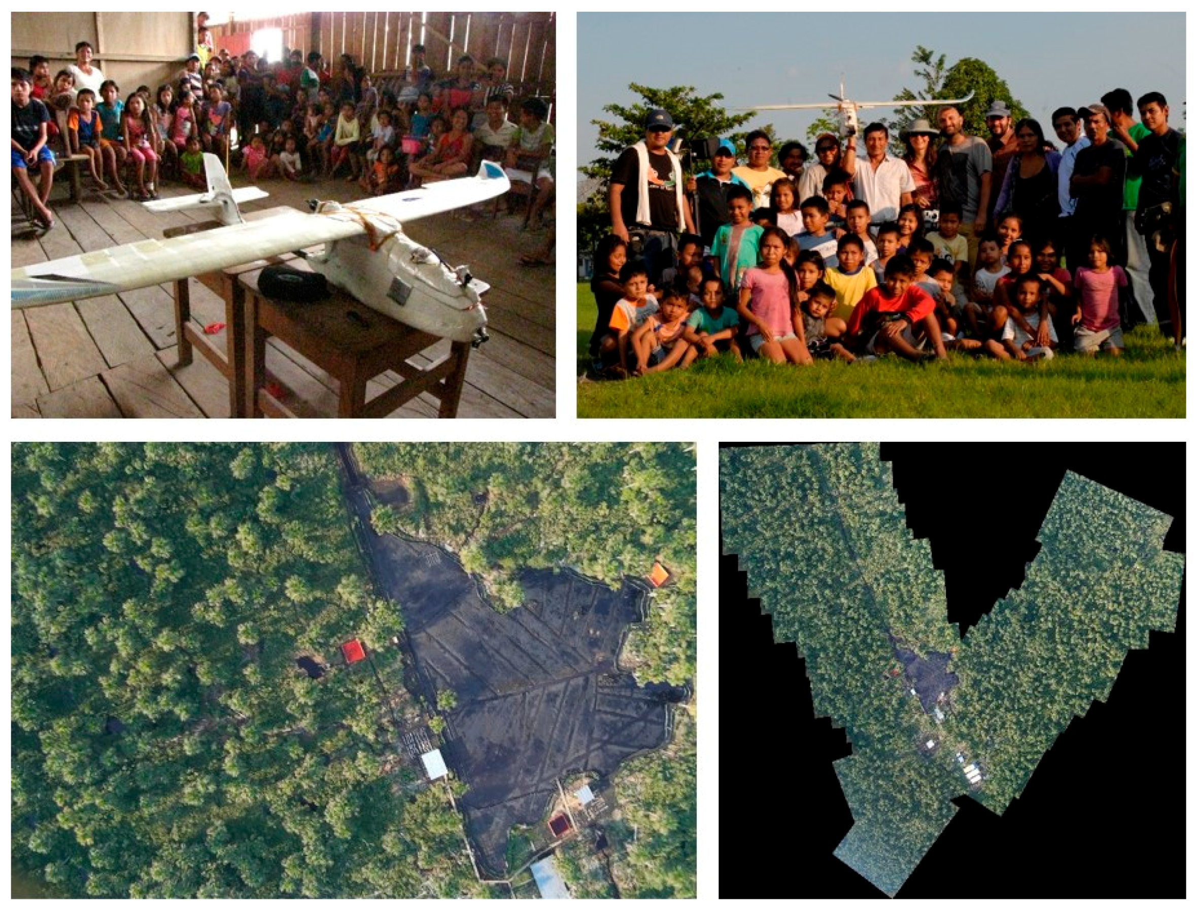
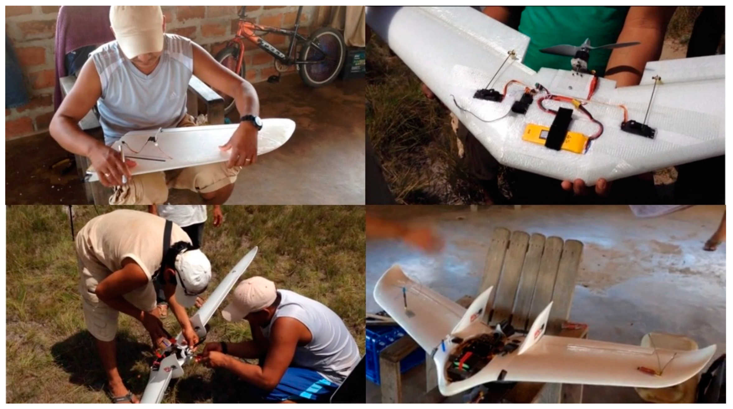
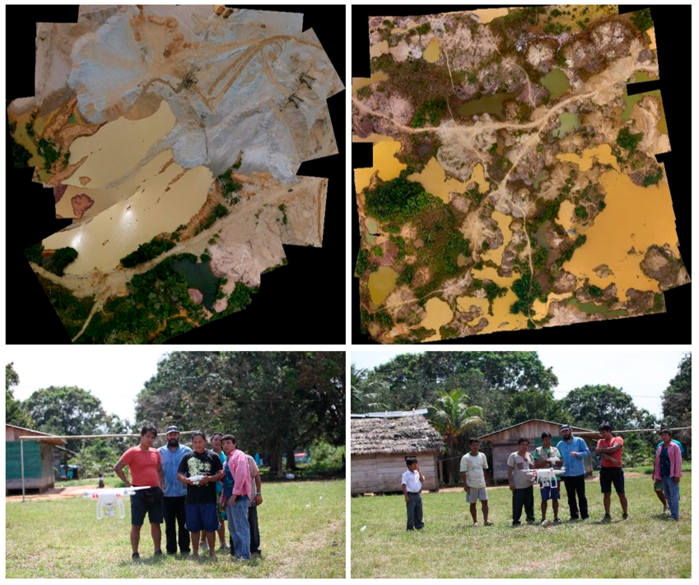
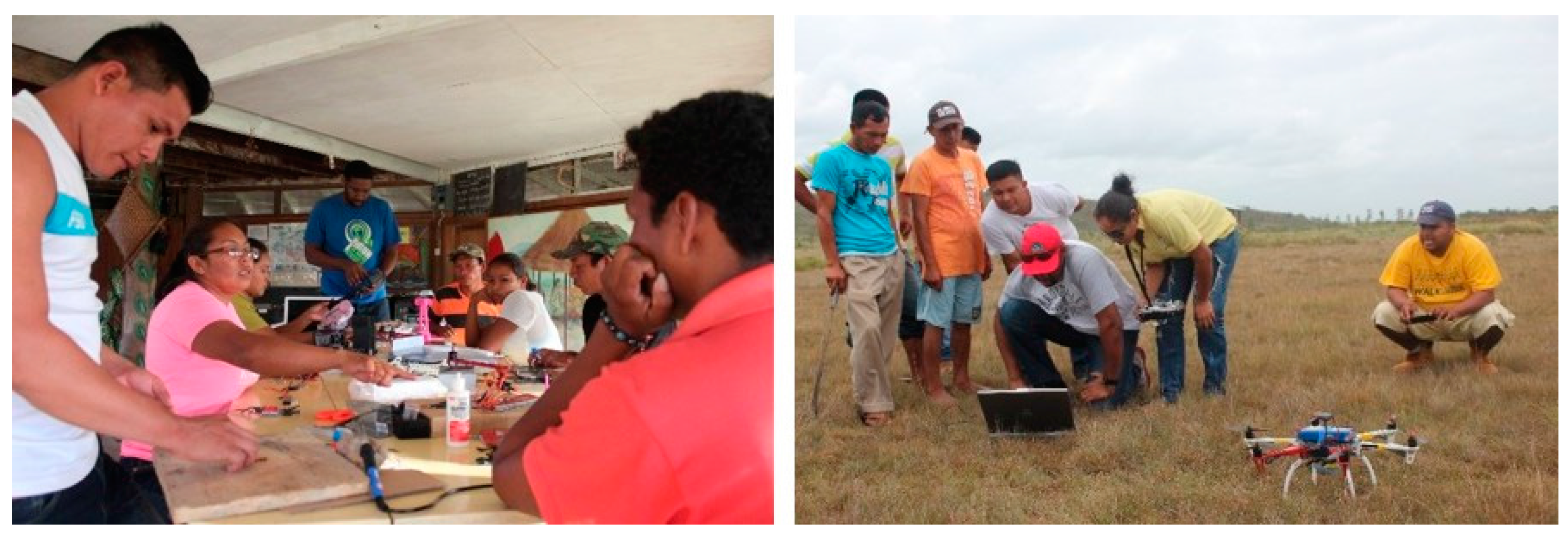
Table 1.
Summary of results from the initial projects described. The order of the columns conforms to the order followed to present the information in the main text.
Table 1.
Summary of results from the initial projects described. The order of the columns conforms to the order followed to present the information in the main text.
| Indigenous Territory | Location (Date) | Participants (Organizers) [Trainers] <Partners> | Mapping & Monitoring Objective | Drone System (Software) | Main Outcomes | Main Challenges | Opportunities Ahead | State of Project |
|---|---|---|---|---|---|---|---|---|
| Kukama Kukamiria | Loreto Department, N. Peruvian Amazon (August 2014) | Kukama Kukamiria, Harakmbut, Emberá (AIDESEP, AMPB, ACODECOSPAT, FENAMAD) [Tushev Aerials] <RFUS, CIGA-UNAM> | Oil spills and impacts | Customized SkyWalker fixed-wing, GoPro 3 & Mobius ActionCam RGB cameras, FPV, Laptop (Mission Planner, ICE, Flight simulator) | Excellent mapping & filming results; Limited manual flying; Limited processing | Limited funding and time; Limited electricity & internet; Insufficient IT/GIS skills; Safety | Environmental protection (oil spills) & territorial defense; Amazonian Indigenous REDD+? | Finished |
| Wapichana & Makushi | S. Rupununi Region, S. Guyana (October 2014) | Wapichana District Toshaos (Chief’s) Council ([Digital Democracy]) <Unknown> | Illegal logging, mining and deforestation | Customized fixed-wing, RGB camera (Mission Planner, Flight simulator, Pix4D Discovery) | Excellent building process; Good manual and autopilot flying; Limited processing | Highly expensive photogrammetric software; Uncertain technological access to prior processing; Lack of landing training | Environmental protection (deforestation) & territorial defense; REDD+? | Unknown |
| Harakmbut | Madre de Dios Department, S. Peruvian Amazon (August 2015) | Harakmbut (AIDESEP, COICA, Hivos, FENAMAD) [CIGA-UNAM] | Illegal gold mining and impacts | Phantom 2 Vision+ (built-in RGB camera), Tablet, Laptop (DJI´s app, ICE) | Excellent mapping & filming results; Limited manual flying; Limited processing | Limited funding and time; Limited electricity & internet; Insufficient IT/GIS skills; Safety | Environmental protection (gold mining, deforestation) & territorial defense; Amazonian Indigenous REDD+? | Finished. Continued but status is unknown at present |
| Emberá–Wounaan | Emberá-Wounaan Region, S. Panama (August 2015) | Emberá-Wounaan (RFUS) [Tushev Aerials] <COONAPIP> | Illegal logging and deforestation | Customized fixed-wing, GoPro3+ camera, FPV, DJI Phantom quadcopter (Pix4D) | Excellent mapping & filming results; Unknown manual flying; Unknown processing | Limited funding and time; Safety | Environmental protection (deforestation) & territorial defense; REDD+ | Continued during 2016. Unknown in 2017 |
| Makushi | N. Rupununi Region, S. Guyana (May–June 2016) | Makushi ([UTD]) <Ministry of Indigenous Peoples Affairs, Hydrometereological Services> | Forest degradation and regrowth; Key natural resources | Assembled hexacopter, Canon A4000 RGB camera (Agisoft Photoscan) | Three-month change detection analysis on a swidden plot | Limited funding for project continuity; Lack of internet access | REDD+; Management plans; Governmental support | Stand-by. Expected to continue in 2018 |
Table 2.
Review of the main benefits and opportunities, as well as problems and challenges, with respect to drone usage with/by IPs (from their own perspective and from others’). NRM: Natural Resource Management; PES: Payment for Ecosystem Services.
Table 2.
Review of the main benefits and opportunities, as well as problems and challenges, with respect to drone usage with/by IPs (from their own perspective and from others’). NRM: Natural Resource Management; PES: Payment for Ecosystem Services.
| Paper | Main Benefits & Opportunities | Main Problems & Challenges |
|---|---|---|
| Paneque-Gálvez et al. 2014 [44] | High-spatial and temporal resolution; enhanced monitoring of forests and illegal activities; access to inaccessible areas; empowerment through data ownership; environmental benefits; Enhanced NRM and monitoring; potential for greater cohesion and institutional strengthening; improved negotiation capabilities in REDD+ and PES programs | Collisions; access to spares; safety; privacy; ethics; Potential for negative social impacts; external dependency for funding, training, supervision, and political and legal advice; increasingly restrictive drone legislation |
| Paneque-Gálvez et al. 2016 [45] | Additional territorial knowledge; avoid/curtail land invasions and environmental damage through drone surveillance; Increasing interest of indigenous peoples for territorial defense & environmental monitoring; popularity of smartphones and digital devices; environmental justice through imagery of environmental damage; institutional strengthening and cohesion | Lack of funding; lack of basic cartographic information; little information on conflicts; little computing skills; lack of electricity, Internet access; privacy; safety; ethics; Poverty and social exclusion; digital illiteracy; external dependency for funding, training, supervision, and political and legal advice; complexity of technology; logistical constraints; potential for conflicts; restrictive drone legislation |
| Radwajali et al. 2017 [46] | High-quality mapping of invasions and environmental degradation; Improved territorial defense and environmental justice; support for land claims; political gains from data and process; potential for social inclusion and liberation | High costs; lack of electricity; isolation; safety; Financial and logistical constraints; dependence on project funding; community cohesion; external appropriation of data; reproduction of social inequalities and power; external support |
| Radwajali et al. [47] | High-quality maps of land invasions and environmental degradation; Furthering territorial claims and recognition of indigenous peoples; detection of land grabs and corporate environmental degradation strengthen environmental justice; potential donors interested (e.g., Ford Foundation, Asia Foundation) | High costs; lack of electricity; isolation; safety; Detrimental social and political effects of counter-mapping: epistemological, socio-economic and political risks |
| Cummings et al. 2017 [43] | Improved mapping and monitoring; improved knowledge of territory; empowerment through data ownership; improved livelihoods; Better NRM; long-term food security; land-use planning; better negotiations in REDD+ and PES programs | Privacy; safety; ethics; lack of good-quality imagery to plan missions; Collision between technology and traditional culture and rights; external, foreign dependence and top-down approaches; little public support in developing countries |
© 2017 by the authors. Licensee MDPI, Basel, Switzerland. This article is an open access article distributed under the terms and conditions of the Creative Commons Attribution (CC BY) license (http://creativecommons.org/licenses/by/4.0/).
Share and Cite
MDPI and ACS Style
Paneque-Gálvez, J.; Vargas-Ramírez, N.; Napoletano, B.M.; Cummings, A. Grassroots Innovation Using Drones for Indigenous Mapping and Monitoring. Land 2017, 6, 86. https://doi.org/10.3390/land6040086
AMA Style
Paneque-Gálvez J, Vargas-Ramírez N, Napoletano BM, Cummings A. Grassroots Innovation Using Drones for Indigenous Mapping and Monitoring. Land. 2017; 6(4):86. https://doi.org/10.3390/land6040086
Chicago/Turabian StylePaneque-Gálvez, Jaime, Nicolás Vargas-Ramírez, Brian M. Napoletano, and Anthony Cummings. 2017. "Grassroots Innovation Using Drones for Indigenous Mapping and Monitoring" Land 6, no. 4: 86. https://doi.org/10.3390/land6040086
Note that from the first issue of 2016, this journal uses article numbers instead of page numbers. See further details here.